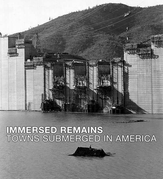
The Center For Land Use Interpretation, which is probably my favorite site on the Web, has a fascinating new exhibit on submerged towns at its Los Angeles office. If you're in the neighborhood, check it out.
I mention this because I linked to a page from CLUI's Land Use Database in my earlier post about chemical weapons, and it reminded me that I don't use - or praise - this remarkable resource often enough.
I stumbled on CLUI in 1996, having been steered to it by the good people at the Museum of Jurassic Technology, next door. It was something of a dream come true for me. I remember driving around Utah in the early 1980s, and being fascinated by the area between Wendover and Tooele. This fascination, I'm sorry to say, was initially nothing more than a morbid aesthetic response: a foolish romantic appreciation of man's ability to make a bleak landscape infinitely bleaker. I subsequently did a lot of research on land use in that region, which taught me a fair amount about Dugway Proving Ground, which in turn taught me a bit more than I wished to know about the moral economy of American power in the 20th century. (Years later, I actually turned down a business-related opportunity to visit Dugway. I suppose I regret it now. Or maybe I don't.)
Anyway, I ended up with an obsessive interest in land use in the desert West, but I rarely had time to study or write about it. Thus, I was overjoyed to discover that CLUI had done a beautiful and thorough job of explaining the manmade landscape, and that they'd done it without resorting either to angry denunciation, or to the infectious - but not always wise - enthusiasm of someone like J.B. Jackson.
CLUI manages to walk a fine line between the artistic fetishization of damaged landscapes, and a nondidactic - but implicitly progressive - approach to encouraging public awareness of land use. For proof, go to the Land Use Database and click on your state; you never know what you'll find! What's especially interesting is how its neutral descriptions of sites, taken en masse, reveal the consistent patterns of military-industrial thinking; the bland, untroubled language of the database is in some ways far more effective than polemic would be.
Their bookstore is terrific, too.
Monday, January 24, 2005
Immersed Remains
Subscribe to:
Post Comments (Atom)
2 comments:
Thanks for posting the link to the Land Use Database. Such an interesting and informative site.
There is something so haunting about seeing large militaristic, energy, chemical complexes in panoramic, so juxtaposed with nature. It's akin to seeing a knife protuding from someone you love.
Here on the Olympic Peninsula, when we drive into town, we pass a huge paper mill nestled ever so angularly on the Port Townsend Bay, spewing great clouds of acrid smelling fumes into the air. And a mere mile across the water is a docking port where huge military ships come in to load bullets and bombs. All surrounded by great blue herons, bald eagles, and the serenity of the Olympic and Cascade peaks.
what a spate of bad news. friday can't come soon enough.
the submerged town i know of, growing up just south of san francisco, is under the local storage lakes of the sf water company. my father remembered the small town now under crystal springs reservoir. and i have read about what the valley was like before crystal springs dam was built. the lakes, i believe, are a surface indication of the san andreas fault. if the dam goes in an earthquake say goodby to downtown san mateo.
i recall vividly the dugway incident. as i rmember the"authorities" tried to deny the whole incident, or blame it on some natural cause.
the other dharma bum
dread pirate roberts
Post a Comment